Calibration and Validation
The calibration of Earth observation imaging sensors hosted on satellite platforms is vital to generate radiometrically and geometrically corrected imagery data that can be scientifically analysed in a consistent manner with ability to perform relative comparison between datasets. A consistent radiometric and geometric correction of imagery data products must be achieved to perform change detection analysis of spatiotemporal collections over time from the same satellite, across multiple satellites in the Wyvern Dragonette constellation, and inter-platform comparisons of datasets acquired from other commercial or science mission satellites (e.g., Landsat, Sentinel, PRISMA, etc.). Consequently, Wyvern has performed a rigorous calibration and validation (cal/val) refinement of each operational satellite in the Dragonette constellation to ensure the best possible quality for every imagery data product.
Wyvern's calibration and validation (cal/val) process involves a radiometric vicarious calibration converting the imagery data pixel units to top-of-atmosphere (TOA) radiance via radiative transfer models and relative TOA reflectance data comparisons. This vicarious calibration approach involves using ground-truth reference imagery over well-characterized calibration sites including PICS, ECCOE, CEOS, CSIRO, RadCalNet and AERONET. Wyvern's radiometric calibration methodology involves routine dark frame snapshot collection with dark signal correction taken at varying exposure and frame intervals to generate results at different sensor temperatures. The pixel bias offsets for each wavelength are computed at 0.1 millisecond integration time. The absolute gain is characterized by converting image pixel units from digital number (DN) into at-sensor radiance. In addition, the cal/val process includes cross-platform radiometric normalization efforts to provide the best possible alignment of Wyvern imagery data products with datasets from the Landsat-8/9 and Sentinel-2 science mission platforms.
In addition to radiometric calibration and normalization efforts, Wyvern's cal/val process includes geometric correction of the data using ground control and reference basemap imagery to achieve best possible independent geolocation accuracy for each individual imagery data product. The consistent georeferencing of imagery data products within standard product specifications for geolocation accuracy enables accurate spatiotemporal analysis of multiple datasets collected over time such as fully-automated change detection and predictive trend analysis.
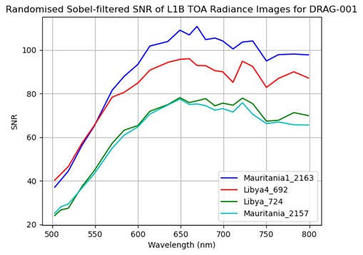
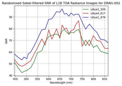
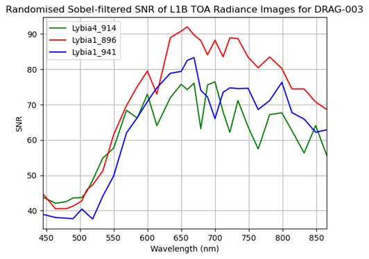
Signal-to-Noise Ratio (SNR)
In the context of imaging, the Signal-to-Noise Ratio (SNR) is a fundamental measure that quantifies the quality of an image by comparing the level of the desired signal (the actual image information) to the level of background noise (random, unwanted fluctuations). A higher SNR indicates a cleaner image where the true image features are more distinct from the noise, while a lower SNR means the noise is more prominent, potentially obscuring details and degrading image quality.
Below is the SNR for each Dragonette satellite for a selection of Pseudo-Invariant Calibration Site (PICS) sites.
Dragonette-1
Dragonette-2
Dragonette-3
Relative Spectral Response (RSR)
Details about the Dragonette relative spectral responses can be found on our GitHub.


