Hyperspectral Imaging
To effectively monitor and map the vast surface of the Earth, satellite-based remote sensing data collection and analysis is required. Wyvern's constellation of Earth observation satellites, ground segment, and product generation system is designed to provide the highest quality high-resolution, accurate, and timely electro-optical imagery. Wyvern's satellites are equipped with hyperspectral imaging (HSI) sensors that collect imagery data in many narrow spectral bands that enables the identification of unique chemical and physical properties of the Earth's surface unlocking novel spectroscopy analysis from space.
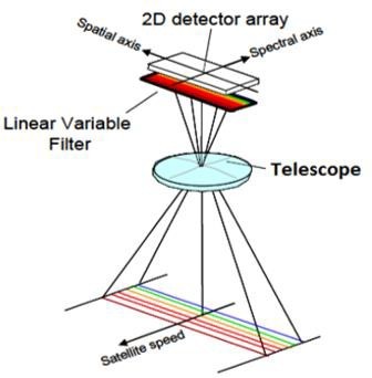
Wyvern's satellites in the Dragonette constellation are equipped with an advanced state of the art high-resolution hyperspectral imaging sensor that collects data in the visible to near- infrared (VNIR) spectral range of the electromagnetic spectrum. Each satellite's imaging sensor is a hyperspectral pushbroom line scan sensor with linear variable bandpass filter primarily designed for Earth Observation (EO) applications as a payload for CubeSats. It is based on a CMOS image sensor and custom continuously variable optical filter in the visible and near-infrared (VNIR) spectral range. The imaging sensor collects sunlight reflected from the Earth's surface then converts this electromagnetic radiation into electrical signals that are recorded via line-scan imaging with 12-bit pixel bit depth. The optical front-end which is used to focus the incoming light onto the focal plane has a large aperture diameter and long focal length within a compact form factor resulting in a high-resolution ground sampling distance (GSD) at operational orbital height altitudes.
Wyvern is using a constellation of small cube satellites (CubeSats) to deliver hyperspectral Earth observation imagery which differs from traditional satellite imagery such as RGB colour imagery or multispectral data as HSI data products have significantly more spectral information. Hyperspectral remote sensing is an imaging spectroscopy technique that collects electro-optical imagery data across dozens of contiguous spectral bands with narrow bandwidths. Hyperspectral imaging sensors capture sunlight reflected from the surface of the Earth in dozens of spectrally narrow bands across VNIR range of the electromagnetic spectrum where natural and anthropogenic materials exhibit distinct spectral signatures.
Consequently, HSI data products enable spectroscopy analytical techniques not available with multispectral imaging (MSI) more commonly available from existing satellite platforms.